Long Distance Hikes - Quick Description
The listed trails below are the trails that I have hiked or plan to hike in the near future. This list will naturally grow as I grow as a hiker. The links below will follow my travels on these amazing trails. In addition to a description of the hike, I have added photographs of all major points of interest on the trail (shelters, intersections, gaps, water sources, views, waterfalls, etc). I hope that this will act as a written description of the trail as well as photographic journal.
Appalachian Trail
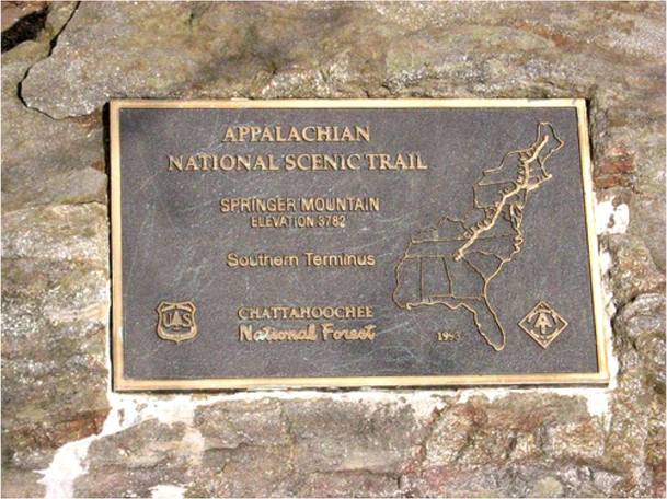 Springer Mountain - June 2014
First there is the Appalachian Trail. The AT is 2,186 mile long trail stretching from Georgia at its southern terminus to Maine at this northern terminus. The AT traverses 14 states.
The AT was conceived by Benton MacKaye who envisioned a footpath from Georgia to Maine.
Whether you are a day hiker, an overnight weekend hiker, a section hiker, or a thru hiker, the AT has everything you need to enjoy the outdoors.
The Bartram Trail
Bartram Trail is likely the most difficult trail to describe. The Bartram trail is named after William Bartram (1739-1823) an American naturalist who explored several southern states, including, Georgia, North Carolina, South Carolina, Florida, Alabama among others. It is not so much on single continuous trail but a series of trails. Can you imagine what that "trail" must have been like when he did it?
For Georgia hikers, the longest and most hiked portion of the Bartram Trail begins in Georgia (approximately 37 miles) and ends in North Carolina (approximately 75 miles). This section is the most established section. The Bartram Trail is yellow rectangular blazed.
For Georgia hikers, the longest and most hiked portion of the Bartram Trail begins in Georgia (approximately 37 miles) and ends in North Carolina (approximately 75 miles). This section is the most established section. The Bartram Trail is yellow rectangular blazed.
Benton MacKaye Trail
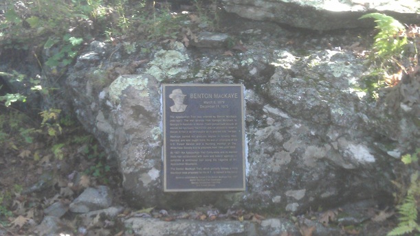 Benton MacKaye Memorial at southern terminus - October 2013
Benton MacKaye, the founder of the AT, has also had an approximately 286 mile trail named after him. The Benton MacKaye Trail begins (or ends, depending on perspective) near the summit of Springer Mountain in Georgia and its northern terminus ends (or begins) near Big Creek in North Carolina.
BMT and the AT share a common starting point near the summit of Springer Mountain. BMT trail intersects with the AT at its northern terminus and its southern terminus making for an amazing loop trail.
BMT is a much more solitary hike and therein lies its charm. It is possible to thru hike the whole trail without seeing more than a handful of people on the trail.
Foothills Trail
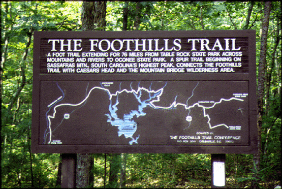
The photograph to the left does a better job describing the Foothills Trail that I ever could. Like the trail name suggests, the Foothills Trail traverses much of the Appalachian Trail foothills with stunning views and amazing waterfalls. If being close to the water is your goal, this trail is for you. There are numerous river crossings with camping locations right by the river, lake, or creek.
This trail also boasts South Carolina's tallest mountain, Sassafras Mt. at 3,563 feet. Furthermore, the Foothills Trail has Upper Whitewater Falls, which is the "highest" waterfall east of the Mississippi at an impressive 411 feet.
This trail hugs the border of GA/SC/NC, but never crosses into GA.
This trail also boasts South Carolina's tallest mountain, Sassafras Mt. at 3,563 feet. Furthermore, the Foothills Trail has Upper Whitewater Falls, which is the "highest" waterfall east of the Mississippi at an impressive 411 feet.
This trail hugs the border of GA/SC/NC, but never crosses into GA.
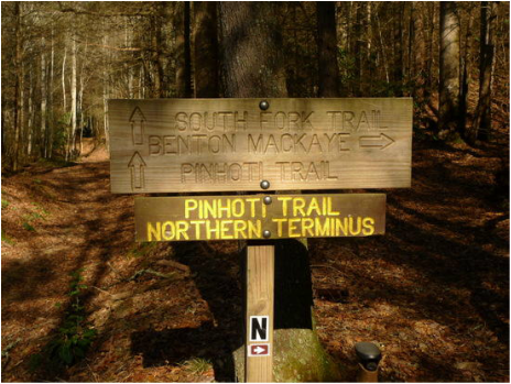
Pinhoti Trail
|
The Pinhoti Trail is another long distance trail that starts (or ends) in Georgia. This trail travels 335 miles from its Northern terminus in Georgia, which it shares with the Benton MacKaye Trail, and travels 335 miles to Flagg Mountain in Alabama.
The Georgia portion of the Pinhoti Trail is approximately 164 miles while the Alabama portion of the Pinhoti Trail is approximately 171 miles. The Georgia Pinhoti Trail is the longest trail in Georgia. |
