The Georgia Hiker - About Us
Foothills Trail - November 2014
I am John. I have lived in Georgia for the better part of my life. Only recently, however, have I really started to explore Georgia. Many call it the "hiking bug." I have it. In spades, i fear.
I first got the bug when I was invited long ago to go hiking by a very good friend back in high school. He was an avid hiker. He knew what he was doing. At that time, I would simply follow him. Never really paying attention to where I was going. Over the years, we went on several hikes. He always took the lead. I always followed. I was amazed how he kept the "map" of what he wanted to hike in his mind. How he never got lost. Unlike my friend, I was (read "am") the type of person to get lost on a one-way street.
Unfortunately, my friend who I would go hiking with left for grad school. Not one of my other friends really hiked. In the hiking world, I was alone and, worse yet, apt to getting lost. The idea of hiking alone was daunting. For a while, this stopped me from hiking, and life went on.
Later that same year, I started looking at local hiking. I remembered that my hiking friend had done a large section of the Appalachian Trail (the "AT") before grad school. As I learned more about the AT, I found several helpful websites. I learned you can day hike the AT. I learned about Blood Mountain and Springer Mountain.
After some very limited research, it was decided. I would conquer Blood Mountain as my first solo hike. I pulled longer nights during the week to free up half a day for a quick hike up to Blood Mountain. The night before the hike, I read the hike description several times. It was a quick and easy trail. "There was no way even someone like me could get lost on this trail," I remember thinking to myself. I went up with no map and little knowledge of the area. I simply had the description of the hike in my mind. I remember parking at Byron Reece Trail Head Parking area. Instead of taking Byron Reece Memorial Trail (I didn't know it even existed at the time!), I walked the quarter mile to Neel Gap. Snapped a few pictures and started making my way up the trail paying careful attention to the white blazes. It was very early, and those white blazes were my friends. My only friends on the trail.
I made may way up the trail and came to my first dilemma: my first intersection. I had reached Flatrock Gap where Byron Reece Memorial Trail, the AT, and Freeman Trail intersect. My memory of the description of this hike made no mention of an intersection (it did, of course, I simply forgot). After a minute, I noted the two side trails "seemed to go down" while the trail in front of me "seemed to go up." Forward I went fairly sure I took the right trail.
I climbed and climbed. I was out of shape. Breathing hard. It was a cold, early morning in November. No one was around. I was alone. With all the downed leaves and lack of green vegetation, the trail was hard to pick up at places. I kept looking for my friend, the white blaze. After a while and close to the top, I stopped. I had come to a place that I didn't know if I needed to "zig" or "zag." I chose to "zag." I should have zigged.
For a good while, I followed what looked like a trail. It appears others have made the same mistake in the past. After a couple of minutes, it started to look a lot less like a trail. It began to narrow. I started to look for my trusty friend. I kept pushing forward for some time to look for my friend. After not seeing it for some time, and no trail in sight, I became worried. I know I was close to the summit, but I started to doubt everything. Had I made the right choice at Flatrock Gap? Was I heading North to North Carolina or South to Springer Mountain? East? West? At the time, I had no clue. I had become so lost that the "trail" I had been following had disappeared, and I wasn't sure I could successfully back track. I decided summits are up. If this was still Blood Mountain, I will find the trail at the top. I kept pushing up the mountain. Luckily, less then two minutes later, I heard voices. People! Civilization! Salvation! I kept pushing up. Eventually I met up with the actual trail.
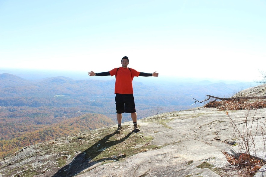
I had made it to the summit! To date, Blood Mountain remains one of my favorite hikes in Georgia. Stunning views and a cool shelter I heard so much about. After taking several pictures, I decided to go back down. And, as I am here creating this website at 3:14 AM several months later, I did so without incident.
When I got home, I immediately looked up Blood Mountain again. I started to look at maps. I started to draw my own map of Blood Mountain. Today, I have done Blood Mountain more times than I can count. From that day forward, I have never looked back. I have done day hikes all over North Georgia. However, a slightly different bug is starting to take hold. This bug demands a tent, a sleeping bag, and a pack! A thru hike is out of the question at this point in my life, but a section hike over an extended holiday weekend is not so out of the question!
The hikes I have on this website will have helpful information regarding trailheads, difficulty, mileage, elevation loss/gain. Furthermore, many of the locations I referenced in the description of the hike can be seen in the gallery to the left. The pictures have the name of location and associated mile marker. The hope is that this will be a picture guide for your upcoming hike!
The purpose of this website still eludes me. Is it a hiking journal for myself? A photographic journal? Is it something I want to keep to show my kids one day? Is it something I wish to show friends? Is it something I wish to show other new hikers to help them on their way? All of the above? None of the above? At this point, I do not know. Whatever this is, I know one thing: the hiking bug in me demands that this website (whatever it is) exist!
I first got the bug when I was invited long ago to go hiking by a very good friend back in high school. He was an avid hiker. He knew what he was doing. At that time, I would simply follow him. Never really paying attention to where I was going. Over the years, we went on several hikes. He always took the lead. I always followed. I was amazed how he kept the "map" of what he wanted to hike in his mind. How he never got lost. Unlike my friend, I was (read "am") the type of person to get lost on a one-way street.
Unfortunately, my friend who I would go hiking with left for grad school. Not one of my other friends really hiked. In the hiking world, I was alone and, worse yet, apt to getting lost. The idea of hiking alone was daunting. For a while, this stopped me from hiking, and life went on.
Later that same year, I started looking at local hiking. I remembered that my hiking friend had done a large section of the Appalachian Trail (the "AT") before grad school. As I learned more about the AT, I found several helpful websites. I learned you can day hike the AT. I learned about Blood Mountain and Springer Mountain.
After some very limited research, it was decided. I would conquer Blood Mountain as my first solo hike. I pulled longer nights during the week to free up half a day for a quick hike up to Blood Mountain. The night before the hike, I read the hike description several times. It was a quick and easy trail. "There was no way even someone like me could get lost on this trail," I remember thinking to myself. I went up with no map and little knowledge of the area. I simply had the description of the hike in my mind. I remember parking at Byron Reece Trail Head Parking area. Instead of taking Byron Reece Memorial Trail (I didn't know it even existed at the time!), I walked the quarter mile to Neel Gap. Snapped a few pictures and started making my way up the trail paying careful attention to the white blazes. It was very early, and those white blazes were my friends. My only friends on the trail.
I made may way up the trail and came to my first dilemma: my first intersection. I had reached Flatrock Gap where Byron Reece Memorial Trail, the AT, and Freeman Trail intersect. My memory of the description of this hike made no mention of an intersection (it did, of course, I simply forgot). After a minute, I noted the two side trails "seemed to go down" while the trail in front of me "seemed to go up." Forward I went fairly sure I took the right trail.
I climbed and climbed. I was out of shape. Breathing hard. It was a cold, early morning in November. No one was around. I was alone. With all the downed leaves and lack of green vegetation, the trail was hard to pick up at places. I kept looking for my friend, the white blaze. After a while and close to the top, I stopped. I had come to a place that I didn't know if I needed to "zig" or "zag." I chose to "zag." I should have zigged.
For a good while, I followed what looked like a trail. It appears others have made the same mistake in the past. After a couple of minutes, it started to look a lot less like a trail. It began to narrow. I started to look for my trusty friend. I kept pushing forward for some time to look for my friend. After not seeing it for some time, and no trail in sight, I became worried. I know I was close to the summit, but I started to doubt everything. Had I made the right choice at Flatrock Gap? Was I heading North to North Carolina or South to Springer Mountain? East? West? At the time, I had no clue. I had become so lost that the "trail" I had been following had disappeared, and I wasn't sure I could successfully back track. I decided summits are up. If this was still Blood Mountain, I will find the trail at the top. I kept pushing up the mountain. Luckily, less then two minutes later, I heard voices. People! Civilization! Salvation! I kept pushing up. Eventually I met up with the actual trail.
I had made it to the summit! To date, Blood Mountain remains one of my favorite hikes in Georgia. Stunning views and a cool shelter I heard so much about. After taking several pictures, I decided to go back down. And, as I am here creating this website at 3:14 AM several months later, I did so without incident.
When I got home, I immediately looked up Blood Mountain again. I started to look at maps. I started to draw my own map of Blood Mountain. Today, I have done Blood Mountain more times than I can count. From that day forward, I have never looked back. I have done day hikes all over North Georgia. However, a slightly different bug is starting to take hold. This bug demands a tent, a sleeping bag, and a pack! A thru hike is out of the question at this point in my life, but a section hike over an extended holiday weekend is not so out of the question!
The hikes I have on this website will have helpful information regarding trailheads, difficulty, mileage, elevation loss/gain. Furthermore, many of the locations I referenced in the description of the hike can be seen in the gallery to the left. The pictures have the name of location and associated mile marker. The hope is that this will be a picture guide for your upcoming hike!
The purpose of this website still eludes me. Is it a hiking journal for myself? A photographic journal? Is it something I want to keep to show my kids one day? Is it something I wish to show friends? Is it something I wish to show other new hikers to help them on their way? All of the above? None of the above? At this point, I do not know. Whatever this is, I know one thing: the hiking bug in me demands that this website (whatever it is) exist!
